
Mackay Marina & Hay Point
Mackay is the first proper harbour after Rosslyn Bay, and after the long run past Shoalwater Bay it's a very welcome sight. The outer harbour is a big breakwater basin that NGA says small craft can enter at any time, and Mackay Marina inside it has fuel, a shipyard and plenty of berths. South of town is Hay Point, one of the biggest coal ports anywhere, with keep-out areas you need to know about before you get there.

- 1Mackay Marina · OSM.
- 2Fuel dock · OSM.
- 3Mackay Harbour ramp · TMR MK20, 4 lanes.
- 4Flat Top Island light · OSM.
- 5Dalrymple Bay · OSM.
- 6Half Tide Tug Harbour ramp · TMR SA31, tide-limited.
At a glance
| What it is | Breakwater outer harbour with a marina, about 2.5 miles south of Slade Point (NGA) |
| Approach | Leading lights on 288° lead north of the Downward Patches (NGA). Flat Top Island light off East Point |
| Depths | Approach channel 8.6 m, swing basin 8.7 m LAT (MSQ 572(T)/2024); marina 3.5 to 4.5 m (NGA) |
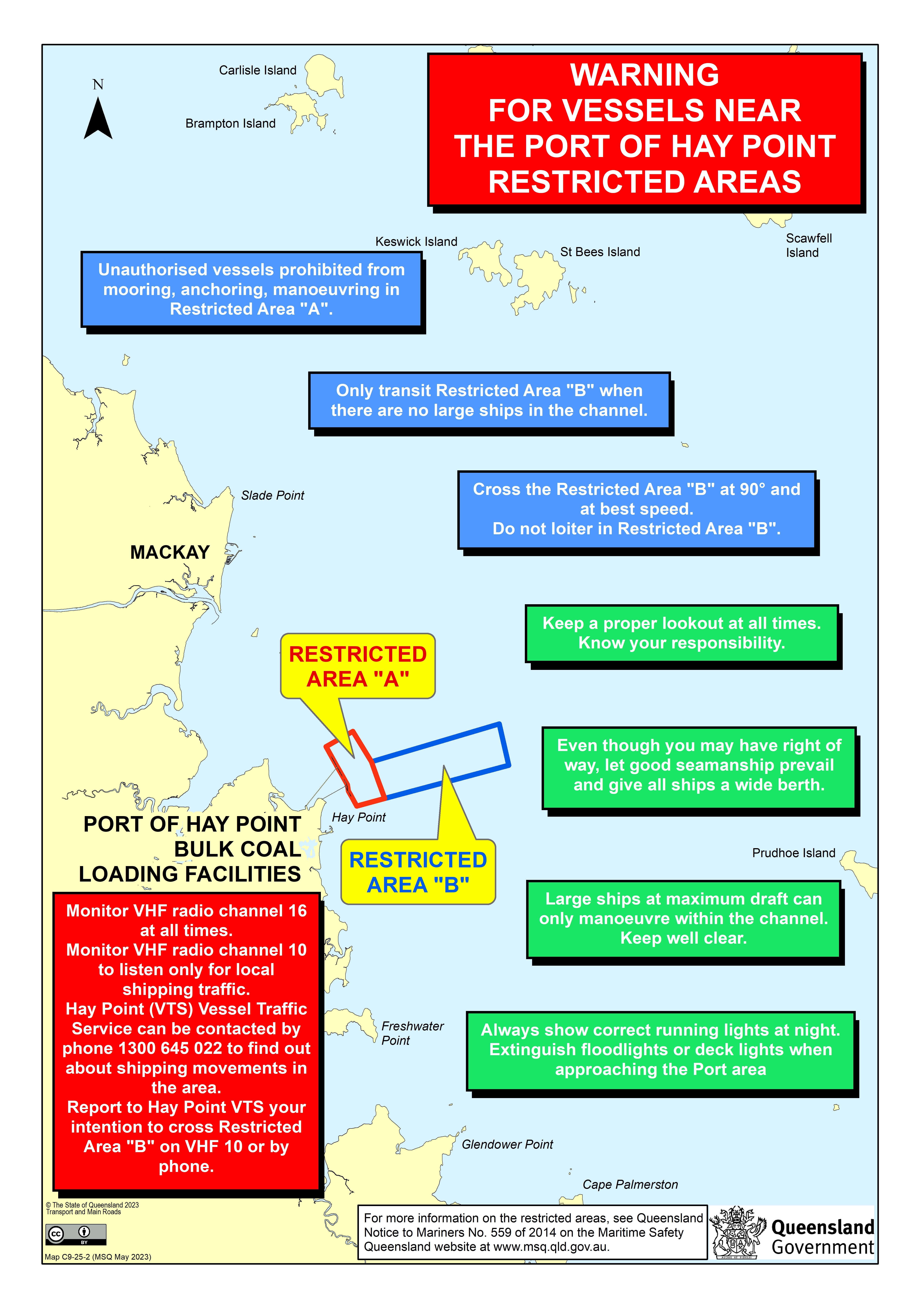
| Hay Point | Restricted Areas A and B; call Hay Point VTS on VHF 10 or 16 (MSQ 440(T)/2026) |
| Weather | Cyclone-prone coast; SE winds very common (NGA) |
Getting here
- Log on/off: VHF 21 or phone (07) 4955 5448. MRQ says it monitors VHF 21, 22 and 80, plus 16 and 67 after hours, 8 am to 6 pm daily
- Emergency: VHF 16 or Triple Zero (000)
Mackay is a breakwater harbour, not a bar, but it's a working port and the last base before the islands. Log on with MRQ Mackay.
Contacts checked on the unit's official website on 19 October 2026: www.mrq.qld.gov.au/rescue-units/mrq-mackay.From the south: Hay Point first. MSQ notice 440(T)/2026 (12 August 2026) says the Harbour Master's direction and the restricted areas off Hay Point are still in force. Unauthorised vessels are not allowed in Restricted Area A or the shipping departure channel. In Restricted Area B you can ask Hay Point VTS on VHF 10 for permission to cross the departure channel when it's clear, and you must cross at right angles and get across quickly. The notice also says to call Hay Point VTS on VHF 10 or 16 when you arrive in or cross Area B, keep a watch on VHF 10 and 16, have your AIS on if you have it, and do what VTS tells you. MSQ's restricted areas map (linked above) shows where the lines are.
Mackay Harbour. NGA says the flood sets south and the ebb north at the entrance. It also warns that strong winds can build heavy seas outside and make boats surge at their berths, more so on a rising tide. Pilotage is compulsory for ships, so keep clear of anything big using the entrance.
Depths. MSQ's 572(T)/2024 gives the approach channel at 8.6 m and the swing basin at 8.7 m below LAT, as of November 2024. It's the latest depth notice we found on the Mackay list, so check for anything newer.
Berths and anchoring
- Mackay Marina. NGA puts marina depths at 3.5 to 4.5 m. The marina's own site lists the office at Mulherin Drive, open 8:30 am to 4:30 pm daily, with fuel, a full-service shipyard and superyacht berths. It says a new northern rock wall now protects the marina from northerly swell.
- Anchoring. NGA mentions large mooring buoys in the north part of the harbour and Love's Jetty (3.4 m) for passenger and pleasure craft. Ask the marina before you drop the pick inside.
Facilities
- Fuel. At the marina fuel dock. The marina says its high-flow system has just been upgraded.
- Haul-out. The marina's shipyard.
- Ramps. Mackay Harbour ramp (4 lanes, TMR) and River Street ramp in town. The Half Tide Tug Harbour ramp near Hay Point is tide-limited, and ⚠ several 2026 Hay Point notices cover remediation works at Half Tide Tug Harbour. ⚠ 567(T)/2026 (23 October 2026): a heavy-lift ship is working at Dalrymple Bay Coal Terminal berth 1 until about 31 October 2026. Keep to 4 knots within 0.5 mile of berth 1 and at least 100 m from the lift ship.
- Overseas arrivals. The marina says Mackay is a clearance port. Talk to Border Force before you sail.
Rules in brief
- Ports. Mackay and Hay Point are separate pilotage areas with their own notices. Hay Point VTS is on VHF 10.
- River. NGA says the Pioneer River at Mackay town is so shallow it dries.
- Marine park. Reef Authority Map 12 covers Mackay.
Ashore
What's within about a 15-minute walk (1.2 km) of each marina, ramp or landing on this page, measured along streets and footpaths in OpenStreetMap. Addresses are from OpenStreetMap where it has one; where it doesn't, we show the name and distance only. ⚠ As at 18 October 2026: we haven't confirmed each place is still trading, so check before you walk.
From Mackay Marina / Mackay Harbour ramp (boat ramp / dinghy landing, marina)
| Name | Type | Walk | Street address (OSM) |
|---|---|---|---|
| Restaurants and cafes | |||
| Sails On The Marina | Restaurant | 190 m | – |
Nothing mapped within the 15-minute walk of: Half Tide Tug Harbour ramp.
No marine stores or chandlers are mapped in OpenStreetMap within the walk; see the Facilities section above for marine businesses we know of.
Places, types, addresses and walking distances: © OpenStreetMap contributors (ODbL), fetched 18 October 2026.
About this page
These are free planning notes written by a working delivery skipper from public sources. They are not for navigation. Use the official chart, current MSQ notices to mariners, official tide tables and local advice. Spotted something out of date? Please use Report a correction below.
Official links
Check these before you go. They beat anything on this page.
- MSQ notices to mariners, Mackay
- MSQ notices to mariners, Hay Point
- MSQ notice 440(T)/2026: Hay Point restricted areas (PDF)
- MSQ notice 572(T)/2024: Mackay Harbour depths (PDF)
- Mackay Marina Village (business site)
- Australian Border Force: arriving by private vessel
- Reef Authority zoning Map 12: Mackay (PDF page)
- MSQ: crossing a coastal bar (safety advice)
- Queensland notices to mariners, all areas (subscribe)
- MSQ Queensland tide tables
- Bureau of Meteorology: tide predictions
- Bureau of Meteorology: Queensland warnings (incl. marine wind warnings)
- Bureau of Meteorology: Queensland coastal waters forecasts
Sources & credits
Written in our own words from NGA Pub. 127 para 7.26 and the MSQ Hay Point restricted areas map and Port of Mackay procedures (no MSQ Beacon to Beacon map covers Mackay) (read 19 October 2026; each MSQ sheet carries its own 'information current to' date, quoted on the page), NGA Pub. 127 Sailing Directions (Enroute) East Coast of Australia and New Zealand (2025), the MSQ notices-to-mariners listings on publications.qld.gov.au (notices named on the page read in full on 19 October 2026; notice lists rechecked 27 October 2026), the Queensland Government (TMR) recreational boating facilities list (fetched 19 October 2026), Marine Rescue Queensland unit pages (checked 19 October 2026), Great Barrier Reef Marine Park Authority zoning pages (linked, not reproduced) and OpenStreetMap. MSQ notices 572(T)/2024 (Mackay depths, 21 November 2024) and 440(T)/2026 (Hay Point restricted areas, 12 August 2026) read in full on 19 October 2026; Hay Point 567(T)/2026 (replaces 539(T)) read in full on 27 October 2026; 228(T)/2026 and the Hay Point 528(T), 527(T), 525(T), 350(T) and 337(T) notices identified by title. Mackay Marina Village website (fact only, 19 October 2026).
Maritime Safety Queensland. Contains Maritime Safety Queensland data (Beacon to Beacon guide, notices to mariners, nav-aid open data, port procedures maps, tide information) © State of Queensland (Department of Transport and Main Roads), licensed under CC BY 4.0. Facts restated and summarised in our own words. Not endorsed by MSQ or TMR.
Queensland legislation. Transport Operations (Marine Safety) Regulation 2016 and Transport Infrastructure (Waterways Management) Regulation 2012 © State of Queensland, CC BY 4.0. Summarised; the authorised versions at legislation.qld.gov.au prevail.
NGA. Background from NGA Pub. 127, Sailing Directions (Enroute) East Coast of Australia and New Zealand (2025), U.S. National Geospatial-Intelligence Agency, a US Government work in the public domain. Parts of it are out of date; where a page leans on it, we say so. Not endorsed by NGA.
OpenStreetMap. Map tiles and some facility positions © OpenStreetMap contributors, data available under the Open Database Licence (ODbL).
Others. Facts from local authority pages and notices (for example the Great Barrier Reef Marine Park Authority, Queensland Parks and Defence notices), volunteer marine rescue sites and businesses' own websites are cited for fact only and restated in our own words. Listing a business is not an endorsement.
Great Barrier Reef Marine Park Authority. Zoning maps and plans of management are linked, not reproduced; the official maps and the zoning plan prevail.
Last checked: 27 October 2026.
Need a boat moved in or out of Mackay?
Get a delivery quoteNeed a delivery skipper for this coast? Get a quote from Capt. Garry Hartshorne, AMSA Master <45.