
Percy Isles & Mackay cruising guide
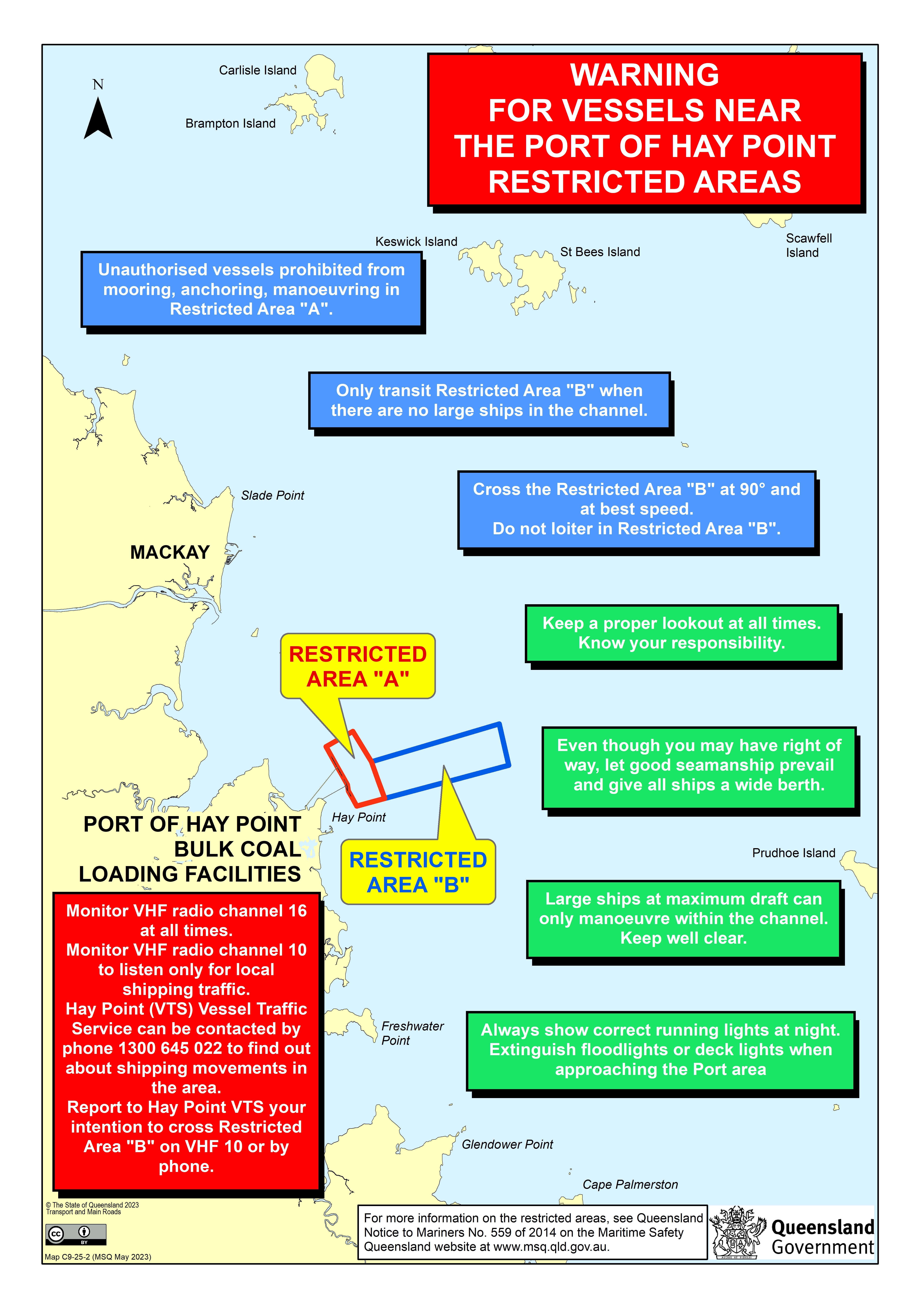
From Shoalwater Bay the inner route runs out past the Percy Isles and the Northumberland Islands, open water with big tides and strong streams, before closing the coast again at Mackay. Mackay's outer harbour is the first proper harbour since Rosslyn Bay, with a marina, fuel and a shipyard. South of it, Hay Point coal port has keep-out areas that need a radio call. North of Mackay, Brampton, Carlisle, Keswick and St Bees start the Cumberland Islands.

- 1Percy Isles & the Northumberlands · Offshore island anchorages
- 2Mackay Marina & Hay Point · Harbour + marina + keep-out areas
- 3Brampton, Keswick & Seaforth · Island anchorages + mainland ramp
Guides in this region, south to north
Percy Isles & the Northumberlands
Offshore island anchorages
The Percy Isles and the Northumberland Islands between Shoalwater Bay and Mackay: anchorages, big tides and strong streams. Free notes.
Mackay Marina & Hay Point
Harbour + marina + keep-out areas
Mackay Harbour and Mackay Marina: the entrance, fuel, the shipyard and clearance, plus the Hay Point restricted areas. Not for navigation.
Brampton, Keswick & Seaforth
Island anchorages + mainland ramp
The southern Cumberland islands north of Mackay: Brampton and Carlisle, Keswick and St Bees, and the Seaforth ramp. Free notes.
Harbours and keep-out areas
- Mackay Marina & Hay Point: Breakwater harbour that small craft can enter at any time (NGA). Hay Point Restricted Area A and the departure channel are off limits.
- Brampton, Keswick & Seaforth: Island anchorages; the Hesket Rock buoy is off station (MSQ 477/2026).
North of Keppel Bay there are no MSQ Beacon to Beacon maps, so carry the current charts.
Neighbouring regions
- South: Keppel Bay & Capricorn Coast
- North: Whitsundays
- Bundaberg to the Whitsundays (section map)
- All cruising guide sections
About these guides
These are planning notes written by a working delivery skipper from public sources: MSQ maps and notices, NGA Pub. 127, the Reef Authority and OpenStreetMap. They are not for navigation. Use the official AHO charts, current MSQ notices to mariners, official tide tables and local advice. Each page shows when its facts were last checked and dates every notice it quotes.
Sources & credits
Maritime Safety Queensland. Contains Maritime Safety Queensland data (Beacon to Beacon guide, notices to mariners, nav-aid open data, port procedures maps, tide information) © State of Queensland (Department of Transport and Main Roads), licensed under CC BY 4.0. Facts restated and summarised in our own words. Not endorsed by MSQ or TMR.
Queensland legislation. Transport Operations (Marine Safety) Regulation 2016 and Transport Infrastructure (Waterways Management) Regulation 2012 © State of Queensland, CC BY 4.0. Summarised; the authorised versions at legislation.qld.gov.au prevail.
NGA. Background from NGA Pub. 127, Sailing Directions (Enroute) East Coast of Australia and New Zealand (2025), U.S. National Geospatial-Intelligence Agency, a US Government work in the public domain. Parts of it are out of date; where a page leans on it, we say so. Not endorsed by NGA.
OpenStreetMap. Map tiles and some facility positions © OpenStreetMap contributors, data available under the Open Database Licence (ODbL).
Others. Facts from local authority pages and notices (for example the Great Barrier Reef Marine Park Authority, Queensland Parks and Defence notices), volunteer marine rescue sites and businesses' own websites are cited for fact only and restated in our own words. Listing a business is not an endorsement.
Great Barrier Reef Marine Park Authority. Zoning maps and plans of management are linked, not reproduced; the official maps and the zoning plan prevail.
Need a boat moved through the Percy Isles & Mackay region?
Get a delivery quoteNeed a delivery skipper for this coast? Get a quote from Capt. Garry Hartshorne, AMSA Master <45.